


***** Update 3 p.m. *****
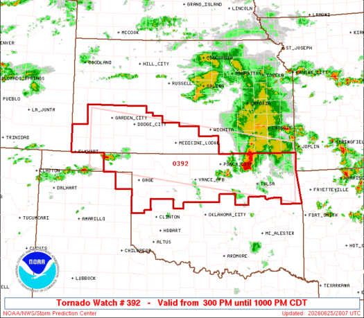
A tornado watch has been issued for all of northeast Oklahoma and southwest Kansas through 10 p.m. tonight. Currently, southeast Kansas is not icnluded in the watch.
.    KANSAS COUNTIES INCLUDED ARE

BARBER               CLARK               COMANCHE
EDWARDS              FINNEY              FORD
GRANT                GRAY                HARPER
HASKELL              HODGEMAN            KEARNY
KINGMAN              KIOWA               MEADE
MORTON               PRATT               SEWARD
STANTON              STEVENS             SUMNER
.    OKLAHOMA COUNTIES INCLUDED ARE

ADAIR                ALFALFA             BEAVER
BLAINE               CHEROKEE            CRAIG
CREEK                DELAWARE            DEWEY
ELLIS                GARFIELD            GRANT
HARPER               KAY                 KINGFISHER
LOGAN                MAJOR               MAYES
NOBLE                NOWATA              OSAGE
OTTAWA               PAWNEE              PAYNE
ROGERS               ROGER MILLS         TULSA
WAGONER              WASHINGTON          WOODS
WOODWARD
****** Original Story *****
Severe weather is possible this afternoon and evening across the four-state area.
Potential hazards include 60 to 70 mph winds, ping-pong ball size hail and a few brief tornadoes. Timing is expected between 4 p.m. and midnight.
The entire four-state area is in the “slight” level 2 out of 5 risk for severe weather, with the greatest risk of a brief tornado in southern Kansas and northern Oklahoma that now includes areas along the state line east to Missouri.
Flooding remains the primary concern with flash flood warnings issued this morning in northeast Oklahoma and a flood watch continues through Friday morning for southeast Kansas, northeast Oklahoma, southwest Missouri and portions of northwest Arkansas.
So far, the month-to-date rain measured at KGGF in Coffeyville is 8.02”.