


A flood warning has been issued for northern Montgomery County in addition to a severe thunderstorm watch through 1 a.m. for the four states.
...FLOOD WARNING IN EFFECT UNTIL 1015 PM CDT THIS EVENING...

* WHAT...Flooding caused by excessive rainfall is expected.

* WHERE...A portion of southeast Kansas, including the following
  county, Montgomery.

* WHEN...Until 1015 PM CDT.

* IMPACTS...Flooding of rivers, creeks, streams, and other low-lying
  and flood-prone locations is imminent or occurring. Expect many
  areas of slow moving or standing water.

* ADDITIONAL DETAILS...
  - At 607 PM CDT, Emergency management reported heavy rain in
    the city of Independence leading to flooded roadways. Between
    1 and 1.5 inches of rain have fallen.
  - Some locations that will experience flooding include...
    Independence, Cherryvale, Elk City, Liberty, Bolton, Elk City
    State Park and Elk City Lake.
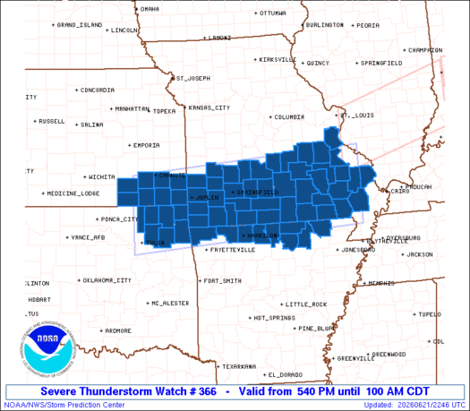
Below is the information on the severe thunderstorm watch in effect through 1 a.m Monday:
.    KANSAS COUNTIES INCLUDED ARE

CHAUTAUQUA           CHEROKEE            CRAWFORD
ELK                  LABETTE             MONTGOMERY
NEOSHO               WILSON
.    OKLAHOMA COUNTIES INCLUDED ARE

CRAIG                DELAWARE            MAYES
NOWATA               OTTAWA              ROGERS
WASHINGTON
.    MISSOURI COUNTIES INCLUDED ARE

BARRY                BARTON              BOLLINGER
BUTLER               CAPE GIRARDEAU      CARTER
CEDAR                CHRISTIAN           CRAWFORD
DADE                 DALLAS              DENT
DOUGLAS              GREENE              HOWELL
IRON                 JASPER              JEFFERSON
LACLEDE              LAWRENCE            MADISON
MCDONALD             NEWTON              OREGON
OZARK                PHELPS              POLK
PULASKI              REYNOLDS            RIPLEY
SHANNON              ST. FRANCOIS        STODDARD
STONE                TANEY               TEXAS
WASHINGTON           WAYNE               WEBSTER
WRIGHT
.    ARKANSAS COUNTIES INCLUDED ARE

BAXTER               BENTON              BOONE
CARROLL              FULTON              IZARD
MARION               RANDOLPH            SHARP