


***** Update 10 p.m. *****
A severe thunderstorm watch has been issued for the four-state area through 4 a.m.
IN ARKANSAS THIS WATCH INCLUDES 4 COUNTIES

IN NORTHWEST ARKANSAS

BENTON                CARROLL               MADISON
WASHINGTON AR

IN OKLAHOMA THIS WATCH INCLUDES 15 COUNTIES

IN EAST CENTRAL OKLAHOMA

CHEROKEE              MUSKOGEE              OKFUSKEE

IN NORTHEAST OKLAHOMA

ADAIR                 CRAIG                 CREEK
DELAWARE              MAYES                 NOWATA
OKMULGEE              OTTAWA                ROGERS
TULSA                 WAGONER               WASHINGTON OK

THIS INCLUDES THE CITIES OF BARTLESVILLE, BENTONVILLE,
BERRYVILLE, CLAREMORE, EUREKA SPRINGS, FAYETTEVILLE, GROVE,
HUNTSVILLE, JAY, MIAMI, MUSKOGEE, NOWATA, OKEMAH, OKMULGEE,
PRYOR, ROGERS, SAPULPA, SPRINGDALE, STILWELL, TAHLEQUAH, TULSA,
VINITA, AND WAGONER.
***** Update 9 p.m. *****
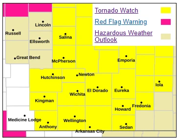
The tornado watch for southeast Kansas has now been extended until 11 p.m. for the following counties:
Butler, Cowley, Allen, Chautauqua, Elk, Greenwood, Wilson, Woodson.
THIS INCLUDES THE CITIES OF ANDOVER, ARKANSAS CITY, AUGUSTA,
CEDAR VALE, EL DORADO, EUREKA, FREDONIA, GRENOLA, HOWARD,
HUMBOLDT, IOLA, LONGTON, MADISON, MOLINE, NEODESHA, ROSE HILL,
SEDAN, WINFIELD, AND YATES CENTER.
***** Update 6 p.m. *****
A tornado watch is now in effect for Osage county in Oklahoma and areas to the west through 11 p.m.
***** Original Story *****
After a break in the weather, severe storm chances are once again possible for the area tonight.
The National Weather Service has issued a tornado watch through 9 p.m. for counties in Kansas along the state line, including Chautauqua and areas to the north and west. Wilson County is also included in the watch, although Montgomery County is not.
Storms are expected to develop between 4 p.m. and 2 a.m., with timing for southeast Kansas largely expected between 7 p.m. and 2 a.m. Up to 2 inch hail, 60-70 mph winds and a few tornadoes are all possible. Stay tuned to KGGF for additional severe weather updates if needed.