


***** Update 3:20 p.m. *****
Severe storms are moving into the KGGF listening area. For the latest information, tune to KGGF AM 690 for live severe weather coverage.
*****Update 2:15 p.m.*****
A tornado watch has been issued for the following areas
OKLAHOMA COUNTIES INCLUDED ARE

ATOKA                BLAINE              BRYAN
CADDO                CANADIAN            CARTER
CLEVELAND            COAL                COMANCHE
COTTON               CRAIG               CREEK
GARFIELD             GARVIN              GRADY
GRANT                HUGHES              JEFFERSON
JOHNSTON             KAY                 KINGFISHER
KIOWA                LINCOLN             LOGAN
LOVE                 MARSHALL            MAYES
MCCLAIN              MCINTOSH            MURRAY
MUSKOGEE             NOBLE               NOWATA
OKFUSKEE             OKLAHOMA            OKMULGEE
OSAGE                OTTAWA              PAWNEE
PAYNE                PITTSBURG           PONTOTOC
POTTAWATOMIE         ROGERS              SEMINOLE
STEPHENS             TILLMAN             TULSA
WAGONER              WASHINGTON          WASHITA
***** Update 1:50 p.m. *****
A severe thunderstorm watch has been issued for the following areas:
IN CENTRAL KANSAS
CHASE
IN SOUTH CENTRAL KANSAS
BUTLER COWLEY SUMNER
IN SOUTHEAST KANSAS
ALLEN CHAUTAUQUA ELK
GREENWOOD LABETTE MONTGOMERY
NEOSHO WILSON WOODSON
THIS INCLUDES THE CITIES OF ANDOVER, ARKANSAS CITY, AUGUSTA,
CEDAR VALE, CHANUTE, COFFEYVILLE, COTTONWOOD FALLS, EL DORADO,
EUREKA, FREDONIA, GRENOLA, HOWARD, HUMBOLDT, INDEPENDENCE, IOLA,
LONGTON, MADISON, MOLINE, NEODESHA, PARSONS, ROSE HILL, SEDAN,
STRONG CITY, WELLINGTON, WINFIELD, AND YATES CENTER.
***** Update 1:20 p.m. *****
The threat of severe weather has increased for northeast Oklahoma. Threats this afternoon include hail up to baseball or softball size and damaging winds up to 80 miles per hour. The most likely timing for northeast Oklahoma and southeast Kansas is between 3 and 7 p.m. tonight.
.png)
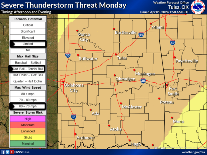
***** Original Story *****
An enhanced risk for severe weather is possible this afternoon and evening for the four-state area.
Storms bringing 70 mph winds, golf-ball-sized hail, brief heavy rainfall and a few possible tornadoes could impact southeast Kansas and northeast Oklahoma between 2 and 10 p.m. today. Timing for storms in southwest Missouri and northeast Arkansas is more likely between 4 this afternoon and 1 a.m. tomorrow. If any tornadoes develop in southeast Kansas, they will be most likely between 6 and 10 p.m. tonight. The better chance for severe weather is east of the Kansas Turnpike. KGGF will provide live severe weather coverage as needed if storms threaten the area.
.png)