***** Update 1:30 p.m. *****
The tornado watch has been extended to now include counties in Kansas, Missouri and Arkansas. All new warnings will be in effect through 9 p.m. tonight.
.    KANSAS COUNTIES INCLUDED ARE

BOURBON              CHEROKEE            CRAWFORD
.    MISSOURI COUNTIES INCLUDED ARE

AUDRAIN              BARRY               BARTON
BATES                BENTON              BOLLINGER
BOONE                CALLAWAY            CAMDEN
CAPE GIRARDEAU       CARTER              CEDAR
CHRISTIAN            COLE                COOPER
CRAWFORD             DADE                DALLAS
DENT                 DOUGLAS             FRANKLIN
GASCONADE            GREENE              HENRY
HICKORY              HOWARD              HOWELL
IRON                 JASPER              JEFFERSON
JOHNSON              LACLEDE             LAWRENCE
LINCOLN              MADISON             MARIES
MARION               MCDONALD            MILLER
MONITEAU             MONROE              MONTGOMERY
MORGAN               NEWTON              OREGON
OSAGE                OZARK               PERRY
PETTIS               PHELPS              PIKE
POLK                 PULASKI             RALLS
RANDOLPH             REYNOLDS            SALINE
SHANNON              ST. CHARLES         ST. CLAIR
ST. FRANCOIS         ST. LOUIS           STE. GENEVIEVE
STONE                TANEY               TEXAS
VERNON               WARREN              WASHINGTON
WAYNE                WEBSTER             WRIGHT
.    ARKANSAS COUNTIES INCLUDED ARE

BAXTER               BENTON              BOONE
CARROLL              CRAWFORD            FRANKLIN
FULTON               JOHNSON             MADISON
MARION               NEWTON              SEARCY
SEBASTIAN            WASHINGTON
***** Update 1 p.m. *****
Ottawa and Craig counties in Oklahoma have been added to the tornado watch through 6 p.m.
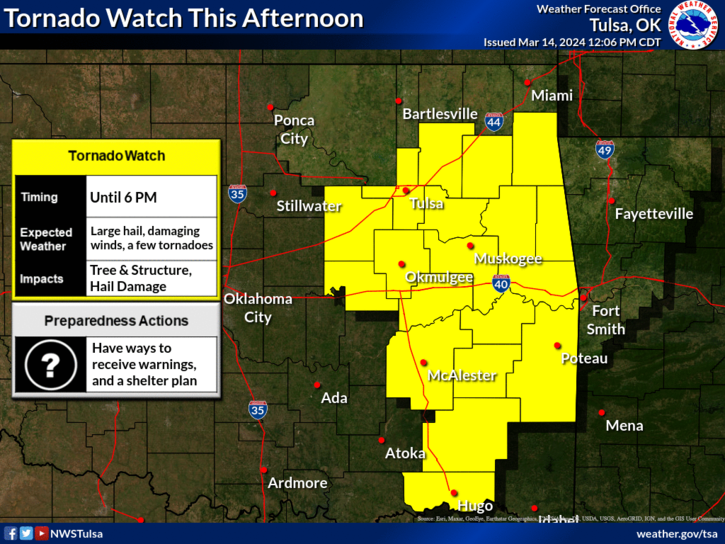
***** Update 12 p.m. *****
A tornado watch has been issued through 6 p.m. for the following counties in Oklahoma:
ADAIR                ATOKA               BRYAN
CARTER               CHEROKEE            CHOCTAW
CLEVELAND            COAL                CREEK
DELAWARE             GARVIN              HASKELL
HUGHES               JEFFERSON           JOHNSTON
LATIMER              LE FLORE            LINCOLN
LOVE                 MARSHALL            MAYES
MCCLAIN              MCINTOSH            MURRAY
MUSKOGEE             OKFUSKEE            OKMULGEE
PITTSBURG            PONTOTOC            POTTAWATOMIE
PUSHMATAHA           ROGERS              SEMINOLE
SEQUOYAH             STEPHENS            TULSA
WAGONER
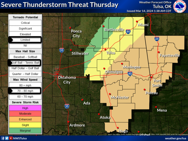
***** Original Story *****
Severe weather is possible this afternoon and evening for the four states.
The main risk will be in southern Missouri, northern Arkansas and eastern Oklahoma, although southeast Kansas including Coffeyville still could see some storms. The most likely onset for storms in southeast Kansas and northeast Oklahoma is between 1 and 8 p.m. today. Hail up to golf ball size and wind gusts up to 70 mph are possible. There's also the chance of an isolated tornado. The best chance of thunderstorms is along and south of the I-44 corridor. If severe weather threatens the area, KGGF will provide coverage as needed.