


***** Update 8:25 p.m. *****
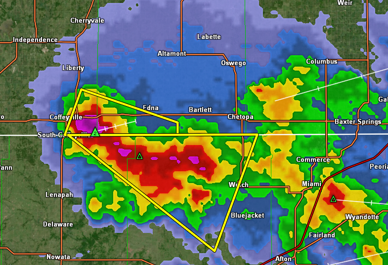
Storms have been moving through the coffeyville area this evening, and a cell moving through Coffeyville into Labette and Nowata and Craig Counties has reached a severe level. Quarter-sized hail and winds up to 60 mph are possible. A flash flood warning has also been issued for part of northeast Oklahoma.
Current warnings:
* Flash Flood Warning for...
Northern Craig County in northeastern Oklahoma...
Northeastern Nowata County in northeastern Oklahoma...
* Until 1130 PM CDT.
* At 829 PM CDT, Doppler radar indicated thunderstorms producing
heavy rain across the warned area. Between 2 and 3 inches of rain
have fallen. The expected rainfall rate is 1 to 2 inches in 1
hour. Additional rainfall amounts of 1 to 2 inches are possible in
the warned area. Flash flooding is ongoing or expected to begin
shortly.
***** Original Story *****
Severe weather is back in the forecast for part of the KGGF listening area.
Storm chances are in the forecast all this week for the four-state area. Today, rain and storm chances will be on the increase, with the best chance for storms being this afternoon through evening. Quarter-size hail and winds between 60 and 70 mph are possible, with the main threat area being southwest of Coffeyville. Multiple rounds of storms are expected, with the most likely development for northeast Oklahoma being between 3 and 7 p.m. tonight. Locally heavy rainfall and flash flooding also cannot be ruled out in some parts of northeast Oklahoma. KGGF will provide severe weather coverage if needed.