***** Update Monday 5:30 a.m. *****
A flood warning remains in effect until 9 a.m. for Neosho and Wilson counties. Between 2 and 4 inches of rain have fallen in the area. Locations impacted include Parsons, Chanute, Neodesha, Fredonia, Erie, St. Paul, Thayer, Altoona, Buffalo, Galesburg, Benedict, Stark, New Albany, Earlton, Coyville, Chanute Airport, Lake Parsons, South Mound and Buxton.
***** Update 10 p.m. *****
* Severe Thunderstorm Warning for...
Southern Craig County in northeastern Oklahoma...
Northeastern Rogers County in northeastern Oklahoma...
Northwestern Delaware County in northeastern Oklahoma...
Ottawa County in northeastern Oklahoma...
Southeastern Nowata County in northeastern Oklahoma...
* Until 1045 PM CDT.
* Locations in or near the path include...
Miami... Vinita...
Grove... Chelsea...
Fairland... Afton...
Bernice... Bluejacket...
Wyandotte... New Alluwe...
Bernice State Park... White Oak...
Narcissa... Ottawa...
Peoria... Pyramid Corners...
Twin Bridges State Park...
***** Update 9 p.m. *****
Severe stroms continue to be possible across the four-state area. Now though 11 p.m., storms producing 1-inch hail and 60 mph wind gusts are possible.
A severe thunderstorm watch has been issued for the following counties in northeast Oklahoma:
ADAIR CRAIG CREEK
DELAWARE MAYES NOWATA
OSAGE OTTAWA PAWNEE
ROGERS TULSA WAGONER
WASHINGTON
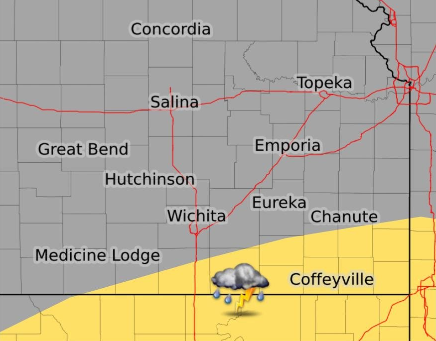
In addition, a flood warning has been issued for the following counties: Allen, Neosho, Wilson and Woodson counties. The warning will be in effect through midnight.
At 802 PM CDT, Doppler radar indicated heavy rain due to thunderstorms. Flooding is ongoing or expected to begin shortly in the warned area. Between 2 and 3 inches of rain have fallen along the Woodson and Wilson county line. Additional rainfall amounts of 1 to 2 inches are possible in the warned area.
- Some locations that will experience flooding include...
Parsons, Chanute, Iola, Neodesha, Fredonia, Humboldt, Yates
Center, Erie, St. Paul, La Harpe, Gas, Moran, Thayer,
Altoona, Toronto, Buffalo, Neosho Falls, Galesburg, Savonburg
and Elsmore.
***** Update 7:15 p.m. *****
The following counties are under a severe thunderstorm watch until 11 p.m. Stay alert for changing weather conditions:
ALLEN                ANDERSON            BARBER
BARTON               BUTLER              CHASE
CHAUTAUQUA           CLARK               COFFEY
COMANCHE             COWLEY              DICKINSON
EDWARDS              ELK                 ELLSWORTH
FRANKLIN             GREENWOOD           HARPER
HARVEY               KINGMAN             KIOWA
LABETTE              LINCOLN             LYON
MARION               MCPHERSON           MONTGOMERY
MORRIS               NEOSHO              OSAGE
PAWNEE               PRATT               RENO
RICE                 RUSSELL             SALINE
SEDGWICK             STAFFORD            SUMNER
WILSON               WOODSON
***** Sunday Morning Update 9:30 a.m. *****
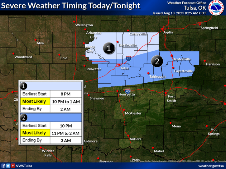
The likelihood of severe weather for the four-state area has increased.
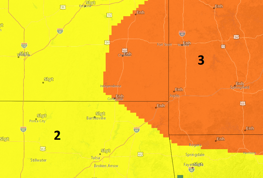
Much of eastern Kansas, western Missouri, extreme northeast Oklahoma and northern Arkansas are now in an enhanced risk of seeing severe weather. Coffeyville and Independence are on the edge, but still included in this risk area. Storms are possible from late afternoon through midnight, with the most likely timing being between 10 p.m. and 1 a.m. for southeast Kansas and northeast Oklahoma. Potential hazards include Damaging winds of 70 mph and 1-2 inch hail. Significant hail of 2.5-3 inches will be possible with isolated storms in southeast KS, and a tornado can’t be ruled out. Torrential rainfall will also be possible. KGGF will provide severe weather coverage if needed. To have multiple ways to stay informed on severe weather, sign up for KGGF text alerts for the county you live in here.
***** Original Story *****
Severe weather is possible again this weekend.
A round of rain has already moved through southeast Kansas and northeast Oklahoma this morning, prompting a flood warning for Allen, Neosho, Wilson and Woodson Counties. Flooding of rivers, creeks, streams, and other low-lying and flood-prone locations is imminent or occurring. Low-water crossings are inundated with water and may not be passable. Some locations impacted include Chanute, Humboldt, Buffalo, Benedict, Earlton, Chanute Airport, Petrolia and Rose. The warning will be in effect until 2 p.m.
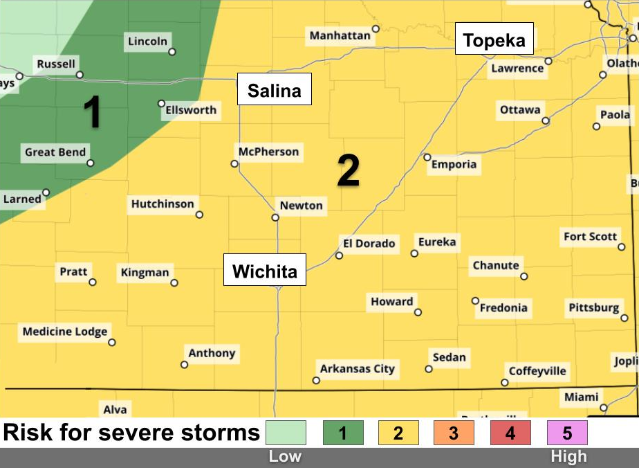
Severe storms are possible today and tomorrow. The better chance for storms will be on Sunday, with 65 mph winds, ping pong-ball size hail, and heavy rainfall possible. Timing both days will be afternoon through overnight hours. KGGF will provide severe weather coverage if needed. Check back here for updates throughout the weekend.
Severe Weather risk for Sunday: